Wake up. Hike. Repeat. Such is life in a tiny desert town with no bars, only a few restaurants, and copious amounts of beautiful red rock to explore.
Of course, there are a few other activities to partake in, like four-wheeling, hunting, or rafting. The point is, you don’t come to Kanab to be inside.
For us, hiking was our usual outdoor routine during our month long dream in this town seemingly cut out from an old western. In fact, it has been the site of many famous westerns from back in the day!
Straddling the border of southern Utah and northern Arizona, Kanab is within a stone’s throw of some of the most fascinating landscapes in the United States.
You might’ve heard the names Zion National Park, Antelope Canyon, and Horseshoe Bend, but hopefully I can enlighten you on even more glorious areas to explore that you haven’t heard of in and near Kanab, Utah.
Looking for more US travel inspiration?
Check out these guides on the best places to visit in…
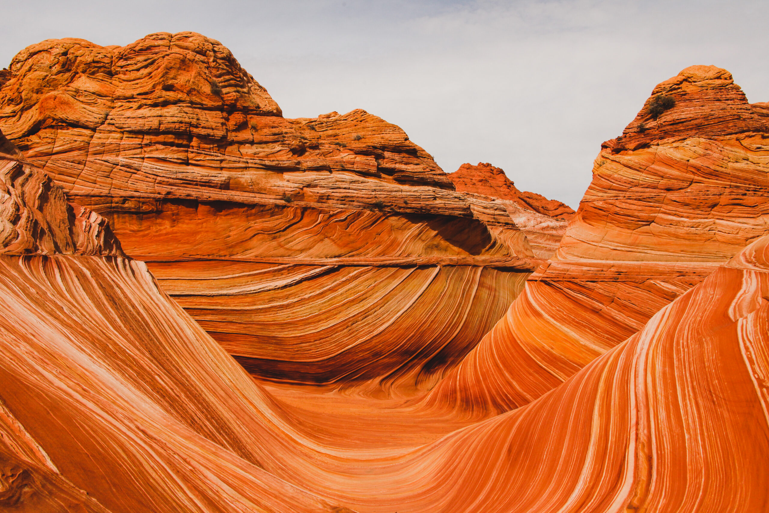
The Wave
Length: 6.7 Miles | Elevation Gain: 1,233 ft. | Difficulty: Hard
Easily the most fascinating hike I’ve ever been on, and I imagine I’m not the only one. It’s going to be hard not to make the typical Mars comparison you often get when discussing this region of the country, but I’m going to try.
First things first, there’s a tough barrier to entry here. You can’t just find the trail on Alltrails and waltz in. You must have a permit to go on this hike or you will face heavy fines and even jail time in some cases! It’s a highly protected area and the permit system is designed to lighten the load on the rock formations that you’ll find in the area.
Unfortunately, getting the permit is a lottery system and takes a bit of luck to win. There are two lotteries, the advanced lottery and the daily lottery. The advanced lottery takes place four months in advance and gives you a better chance of winning, while the daily lottery takes place every day to decide who goes the next day.
Even if you do win, the road to the trailhead can be spotty! If it rains, it’s pretty much impassable. If it’s dry, you should be just fine.
With all that being said, put yourself in the race for the privilege of going on this hike, because it’s one of the best. It’s this exclusive for a reason, and that reason is it’s a mind-bending journey through the desert through some of the most bizarre rock formations you’ll find.
I can write much more about this hike, but this bit has already gotten pretty long… so if there’s one takeaway, it’s this: this is hands down one of the best hikes you can do near Kanab.
You can find maps and more info here.
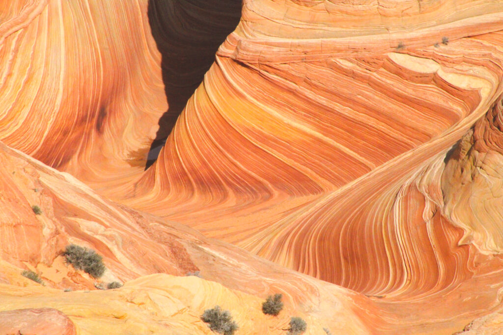
The Wave by Daniel Hayes (IG: indecisive_travels)
Wire Pass to Buckskin Gulch
Length: 5.6 Miles | Elevation Gain: 616 ft. | Difficulty: Moderate
If you didn’t win The Wave lottery, don’t take it too hard. There are many extraordinary hikes to go on nearby that are in the same echelon of hiking.
For instance, one of the best hikes near Kanab is Buckskin Gulch. Don’t worry about a lottery here, although there is a permit requirement that costs about six bucks.
You do have to travel a couple miles down a dirt road that can be impassable when wet. It’s best to have vehicles with high clearance and 4WD/AWD, but it is doable without those when the road is dry.
This hike starts out by following a wash about 1.3 miles in before reaching a labyrinth of incredible slot canyons. The entrance to the canyons will appear to you as if it’s a mirage, but it’s not, you’ve reached your shady respite.
You’ll enter the canyons like you would an abandoned city, gazing up along the towering smooth walls and to a narrow sky peaking in from above. It’s hard not to lose track of how far you’ve gone when you’re constantly tempted to see what’s around the next bend, so just remember you have to turn back eventually!
If you find yourself in southern Utah, you must take advantage of the many slot canyons to explore. Buckskin Gulch is definitely one of the coolest hikes you can find near Kanab, Utah.
Despite the cool shade on much of this journey, when hiking in this region you MUST consider the heat. We were there in February so it wasn’t as much of a concern, but if you’re going in the summer always make sure to bring plenty of water and cover up. It’s also always best to go early in the morning and beat the heat.
You can find maps and more info here.
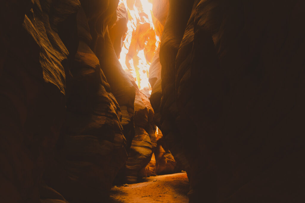
Buckskin Gulch slot canyon by Daniel Hayes (IG: indecisive_travels)
Toadstool Hoodoos Trail
Length: 1.8 Miles | Elevation Gain: 141 ft. | Difficulty: Easy
Here’s an easy hike near Kanab! And don’t worry – easy does not equate to less spectacular.
This trail begins on the southern border of Escalante National Monument where you follow a wash until you see a magnificently balanced rock atop a narrow stem. It looks just like a toadstool mushroom, so now you know where the name came from!
While the first one is the most famous in the area, if you keep exploring you’ll find many more. It’s a wonderful place to run around and explore, weaving in and out of the washes and seeing what rock formations you can find.
This is an excellent place to get some funky photos while letting the kiddos run around and climb on the rocks.
Being free to use and easily accessible from the main road between Kanab and Page, AZ, this is one of the best hikes near Kanab, offering a laid back adventure that you must check out when visiting Kanab and the surrounding area.
You can a map and more info here.
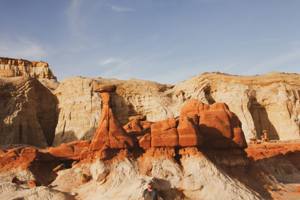
Toadstool by Daniel Hayes (IG: indecisive_travels)
Sand Caves
Length: 1.4 Miles | Elevation Gain: 124 ft. | Difficulty: Easy
Another easy one as far distance and elevation gain goes, this hike near Kanab is almost barely a hike and more a place to walk around and explore.
Pulling off to the side of highway 89 just north of Best Friends Animal Sanctuary (a must visit), you’ll notice a few small caves up on the cliff face. Your objective is to enter those caves.
It’s a short walk to the cliffside, where you’re able to scramble up towards the caves. I know the thought of scrambling a cliff sounds intimidating, but it’s more a steady climb for maybe 100 feet. There were kids whizzing by us on the way up when we went, making me feel older than the caves themselves.
Once you get to the caves, you can weave through them peering out of the windows and admiring the cave walls made of sand.
An interesting, free, and relatively easy place to access, this hike makes an awesome adventure for the family. After that, you’ll be right next to the Moqui Museum to escape the sun.
You can a map and more info here.
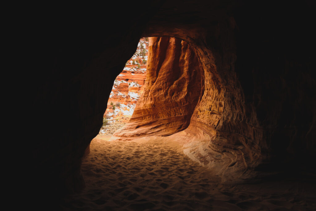
Sand Caves by Daniel Hayes (IG: indecisive_travels)
Coral Pink Sand Dunes Trail
Length: 0.8 miles | Elevation Gain: 85 ft. | Difficulty: Easy
I promise we’ll get to more traditional and lengthy hikes, but these (relatively) easy hikes near Kanab must be mentioned.
As I said, ease does not equate to less spectacular, but don’t underestimate the difficulty of trudging through sand. At Coral Pink Sand Dunes, that’s essentially what you’ll be doing.
This “hike” brings you to center of beautifully pink sand dunes.
While there is plenty of places to find sand in the area, the concentration and the color of the sand here make it a truly unique experience.
Along with hiking, visitors can go off-roading and even sledding and sand boarding.
The park is ten bucks to enjoy and there’s even camping areas. It’s easy to get to with the road to the entrance right off highway 89.
No doubt, I’d recommend this as a must see place for those visiting the area, especially if you want some spectacular photos.
NOTE: I could copy and paste this message into every hike on this list, but beware of the heat! As most deserts and sand dunes, this place is completely exposed and can be very dangerous in the summer months. That being said, go early in the morning or in the off-season to hike in one of the most fascinating areas near Kanab, UT.
You can a map and more info here.
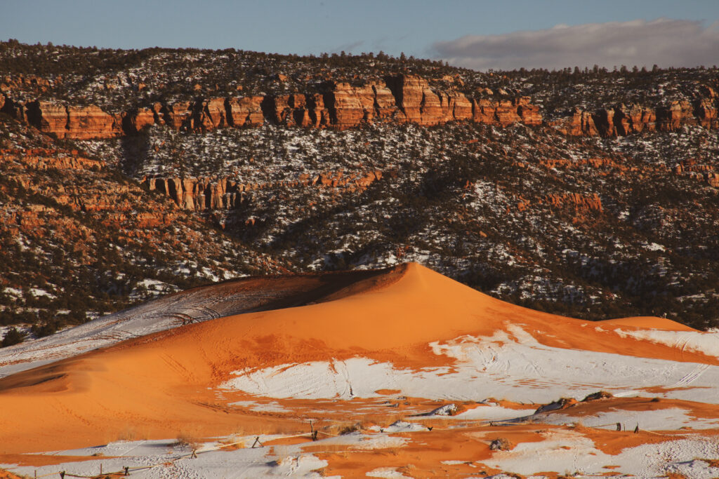
Coral Pink Sand Dunes in Winter by Daniel Hayes (IG: indecisive_travels)
Kanab City to Connector Trail
Length: 3.2 miles | Elevation Gain: 738 ft. | Difficulty: Moderate
This trailhead is located right in town at Jacob Hamblin Park, making it very easy to access for anyone in the Kanab area. Best described as moderately challenging, this hike takes you up through the red rock overlooking the town from the north.
With a few switchbacks and some decently steep sections, this is a great hike near Kanab to get the heart pumping.
As you hike up into the canyon, the view of Kanab and the surrounding area gets better and better. By the time you reach the top, your view will be panoramic, and you’ll have the best seat in the house to examine all of the gorgeous red rock surrounding Kanab.
NOTE: It’s fairly exposed throughout, although if you go during the early morning you can be greeted by the shade. Once you get back down, walk into town and grab a fresh beer and some grub at Rocking V Cafe. They never let us down.
You can a map and more info here.
East Rim Trail to Overlook
Length: 4.5 miles | Elevation Gain: 547 ft. | Difficulty: Moderate
About 30 minutes north of Kanab is a little lesser known Utah park called Zion. Kidding, it’s a U.S. National Park juggernaut that anyone who is reading lists about hiking has probably heard of. If we’re talking Kanab and the surrounding area hikes, it would be a mistake not to mention at least one or two hikes in Zion.
For this one, I’m going to take a different approach. You can easily find a list of Zion hikes littered with household trailheads such as Angel’s Landing and the Narrows, but I’ll give you one near the less populated east entrance of the park which is closer to Kanab.
Zion is probably my favorite National Park, which is one of the reasons Kanab was so enticing for us to spend time in. Close to Zion, but slightly more off the beaten path and less expensive than gateway town Springdale.
This trail gives you a unique perspective of the park and an amazing view of Checkerboard Mesa. Leading up to those views is a very peaceful journey through the East Canyon.
Despite the sand you have to trudge through and some switchbacks, this hike is relatively easy-going. There is a lack of cover so, [enter hot weather warning here]. There are dozens of incredible hikes in Zion and this hike is definitely one of them!
You can a map and more info here.
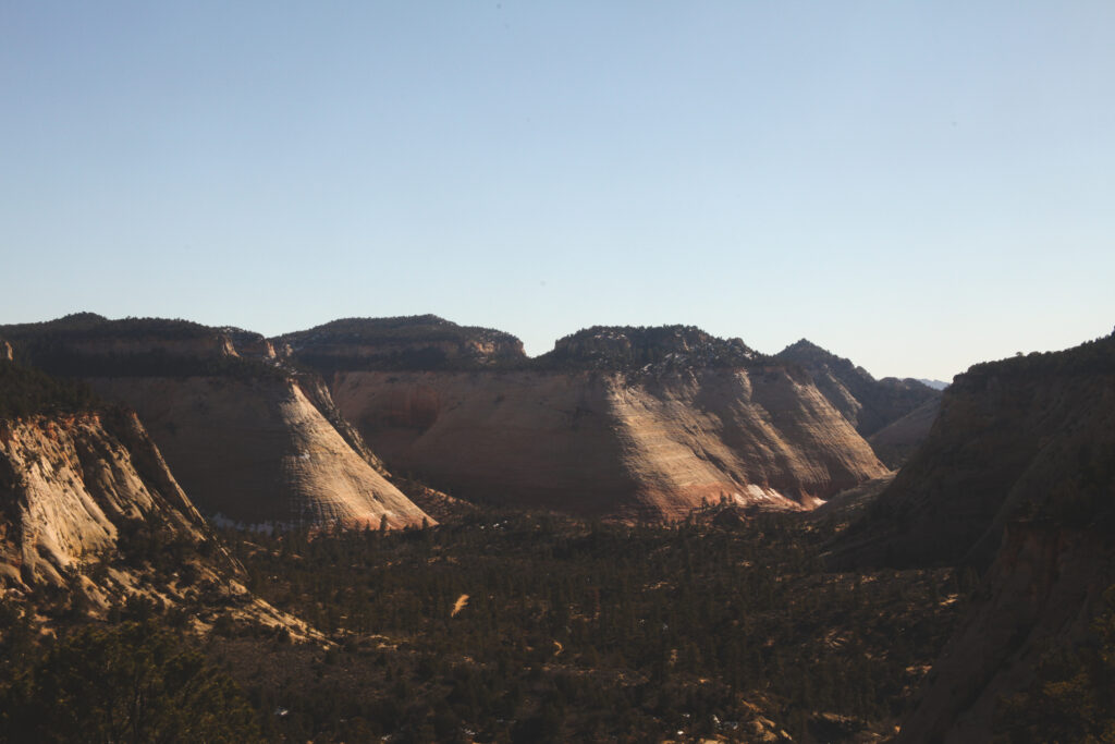
View from overlook in Zion NP by Daniel Hayes (IG: indecisive_travels)
The Narrows (Bottom up)
Length: 8.9 miles | Elevation Gain: 695 ft. | Difficulty: Hard
Now that I mentioned one lesser-known Zion trail, I’m going to pick one big name hike and that’s the Narrows. This easily could’ve been Angel’s Landing, but the Narrows is one of the most unique hiking experiences you can take on in the country.
It’s an epic slot canyon that stretches for miles and miles. You can take it as far as you want, but I’ll warn you that it’s hard to turn around and head home.
The big obstacle here is water. For huge stretches of this hike, you’re knee deep in water balancing on bedrock which makes each step that much more difficult.
However, the challenge is well worth it. Of course, the farther you get in and away from the crowds, the more peaceful and majestic this canyon becomes. It ain’t easy, but you will not regret giving this hike a go.
Being as famous a hike as it is, you’re going to face crowds so prepare yourself for that. It also means you’ll have to take the shuttle to the trailhead which could mean long lines.
As always, the recommendation is to go early.
You’ll see a lot of people wearing fancy drysuits, boots, and using hiking sticks that they rented from the local adventure shops. It’s up to you whether you rent anything, but we did not use any of those things, and have a wonderful time.
I will say, a stick was helpful, but pro tip: hikers from before you often leave perfectly good and free hiking sticks at the trailhead!
You can a map and more info here.
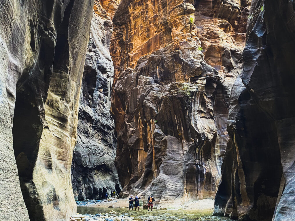
View from the Narrows Trail by Daniel Hayes (IG: indecisive_travels)
Hat Shop Trail
Length: 4 mi | Elevation gain: 967 ft | Difficulty: Moderate
If we’re talking National Parks, there’s another one close enough to Kanab that I think it’s well worth the 1-1.5 hour drive. I’m referring of course to Bryce Canyon, the strange other-worldly land of hoodoos.
There are dozens of trails to explore in this relatively condensed National Park, and I’m going to give you one that may be a little less populated.
The Hat Shop trail brings you down into the depths of Bryce Canyon along many stunning hoodoos and cliff faces before heading back up to a spectacular view of a collection of toadstools adorably named the hat shop.
Bryce Canyon is a must visit for anyone visiting southern Utah and the Kanab area, and this hike will give you a unique perspective of the park!
Another thing I loved about this hike was the fact that we only saw one other person on the trail.
Fun fact, Paiute lore believed that the tall red rock hoodoos were “evil legend people” turned to stone by a Coyote spirit.
You can a map and more info here.
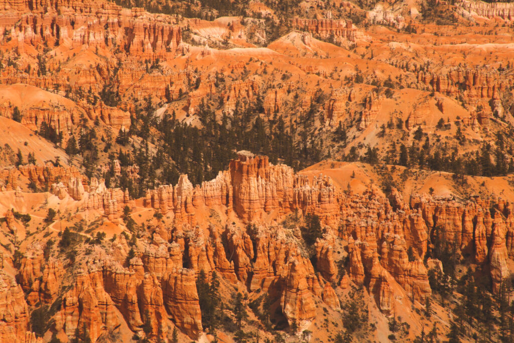
View from Hat Shop Trail by Daniel Hayes (IG: indecisive_travels)
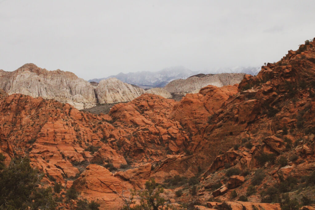
Padre Canyon via Tuacahn Trail
Length: 2.9 mi | Elevation Gain: 744 ft. | Difficulty: Moderate
Just outside the town of St. George, about an hour west of Kanab, you’ll find more incredible hiking areas. One of our favorites we visited from Kanab was Snow Canyon State Park. This hike takes you up and over strikingly colorful lava flows and sandstone cliffs to a splendid panoramic view of the surrounding red landscape.
I would place this hike somewhere in between moderate and difficult.
While it’s not the longest hike, it gets steep in a lot of areas and can be a scramble. You might find yourself thinking, “oh, I’m rock climbing today.” That being said, it’s very doable for folks with decent fitness.
At the intersection of the Mojave Desert, Great Basin, and Colorado Plateau, this place has a unique mix of desert wildlife and vegetation. You’ll also find caves to explore on the way to the top!
Like many on this list, there’s not much cover on this trail, so keep that in mind during the summer months.
You can a map and more info here.
Mansard Great Diverse Trail
Length: 5.3 mi | Elevation Gain: 1,223 ft. | Difficulty: Moderate
The Mansard Great Diverse Trail is a very unique hike that takes you up to Mansard Cove. What makes it unique is that it features petroglyphs dating back to 0 AD. I love hikes that feature petroglyphs. Let your imagination run wild thinking about the people before you who did this trek all those years ago.
The hike is generally regarded as moderate, but there are some steep sections that get your heart pumping. Alongside the beautiful petroglyph panel featured in the cove, you also have an incredible view of the surrounding area.
This is a great hike for those visiting Kanab, especially if like to imagine what you’d be like if you were born during the time of the petroglyphs on the walls. The though of myself even trying to start a fire out there makes me laugh.
You can a map and more info here.
Did we miss any of your favorite hikes in or around Kanab?
Let us know in the comments so we can add more recommendations to our list!